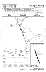
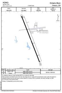


KONO - Ontario Muni
Located in Ontario, United States
ICAO - ONO, IATA -
Data provided by AirmateGeneral information
Coordinates: N44°1'10" W117°0'47"
Elevation is 2193 feet MSL.
Magnetic variation is 13° East View others Airports in Oregon
Operational data
Special qualification required
Current time UTC:
Current local time:
Weather
METAR: KONO 271253Z AUTO 25011KT 10SM CLR 09/02 A2991 RMK AO2 SLP127 T00940022
TAF: KONO 271120Z 2712/2812 33014G24KT P6SM SCT070 BKN100 FM271600 27010KT P6SM SCT060 BKN200 FM280100 33006KT P6SM OVC100 FM281000 VRB05KT P6SM BKN200
Communications frequencies: [VIEW]
Runways:
| RWY identifier | QFU | Length (ft) | Width (ft) | Surface | LDA (ft) |
| 15 | 158° | 5006 | 100 | ASPH | |
| 33 | 338° | 5006 | 100 | ASPH |
Airport contact information
Address: Ontario United States