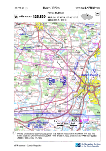


LKPRIM - Horni Prim
Located in 5 Km E Nechanice, Czech Republic
ICAO - , IATA -
Data provided by AirmateGeneral information
Coordinates: N50°13'46" E15°42'13"
Elevation is 885 feet MSL.
View others Airports in Hradec Králové Region
Operational data
Special qualification required
Current time UTC:
Current local time:
Weather at : LKPD - Pardubice ( 24 km )
METAR: LKPD 061030Z VRB03KT CAVOK 17/13 Q1009 NOSIG RMK BLU BLU
TAF: TAF LKPD 060500Z 0606/0706 04004KT CAVOK TEMPO 0612/0618 06008KT 7000 SHRA SCT030TCU PROB30 TEMPO 0613/0618 5000 TSRA SCT020CB BECMG 0700/0702 6000 RA BKN020 OVC040 TEMPO 0702/0706 4000 RA BR OVC014
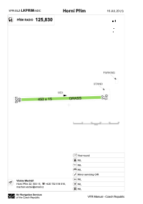
Communications frequencies: [VIEW]
Runways:
| RWY identifier | QFU | Length (ft) | Width (ft) | Surface | LDA (ft) |
| 09 | 88° | 1476 | 49 | GRASS | 1476 |
| 27 | 268° | 1476 | 49 | GRASS |
Airport contact information
Address: 5 Km E Nechanice Czech Republic