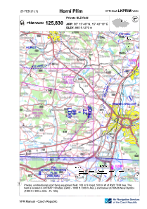
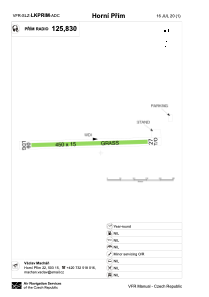


LKPRIM - Horni Prim
Located in 5 Km E Nechanice, Czech Republic
ICAO - , IATA -
Data provided by AirmateGeneral information
Coordinates: N50°13'46" E15°42'13"
Elevation is 885 feet MSL.
View others Airports in Hradec Králové Region
Operational data
Special qualification required
Current time UTC:
Current local time:
Weather at : LKPD - Pardubice ( 24 km )
METAR: LKPD 190030Z VRB01KT CAVOK 11/10 Q1011 RMK BLU
TAF: TAF LKPD 182300Z 1900/2000 VRB02KT 9999 SCT030 TEMPO 1900/1906 4000 SHRA BR SCT010 BKN020TCU PROB30 TEMPO 1900/1906 1000 MIFG BKN003 TEMPO 1906/1922 6000 SHRA BKN024TCU PROB40 TEMPO 1912/1922 16014KT 3000 TSRA BKN016CB
Communications frequencies: [VIEW]
Runways:
| RWY identifier | QFU | Length (ft) | Width (ft) | Surface | LDA (ft) |
| 09 | 88° | 1476 | 49 | GRASS | 1476 |
| 27 | 268° | 1476 | 49 | GRASS |
Airport contact information
Address: 5 Km E Nechanice Czech Republic