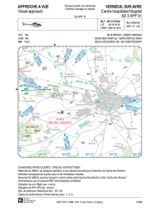


LFH388 - Verneuil Sur Avre Centre Hospitalier
Located in , France
ICAO - , IATA -
Data provided by AirmateGeneral information
Coordinates: N48°44'40" E0°53'30"
Elevation is 597 feet MSL.
Magnetic variation is 0.58° East View others Airports in Upper Normandy
Operational data
Special qualification required
Current time UTC:
Current local time:
Weather at : LFOE - Evreux Fauville ( 40 km )
METAR: LFOE 280030Z AUTO 17013KT 9999 SCT011/// SCT042/// BKN064/// ///TCU 10/09 Q1000 BECMG 20015G25KT RA BKN015
TAF: TAF LFOE 272000Z 2721/2821 15007KT 7000 RA SCT045 BKN050 BECMG 2722/2724 BKN010 BECMG 2802/2804 20015G25KT BKN015 TEMPO 2813/2818 4000 SHRA BKN020CB BECMG 2818/2819 14003KT
Communications frequencies: [VIEW]
Runways:
Airport contact information
Address: France