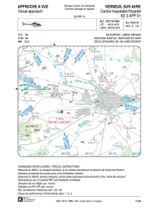


LFH388 - Verneuil Sur Avre Centre Hospitalier
Located in , France
ICAO - , IATA -
Data provided by AirmateGeneral information
Coordinates: N48°44'40" E0°53'30"
Elevation is 597 feet MSL.
Magnetic variation is 0.58° East View others Airports in Upper Normandy
Operational data
Special qualification required
Current time UTC:
Current local time:
Communications frequencies: [VIEW]
Runways:
Airport contact information
Address: France