


LFH218 - Val D'isere La Daille
Located in , France
ICAO - , IATA -
Data provided by AirmateGeneral information
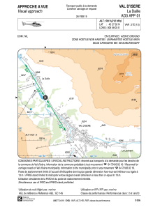
Coordinates: N45°27'26" E6°58'4"
Elevation is 5910 feet MSL.
Magnetic variation is 2.35° East View others Airports in Rhône Alpes
Operational data
Special qualification required
Current time UTC:
Current local time:
Weather at : LIMW - Aosta ( 44 km )
TAF: TAF LIMW 300500Z 3006/3015 VRB05KT 9999 SCT080 BECMG 3010/3012 10015KT
Communications frequencies: [VIEW]
Runways:
Airport contact information
Address: France