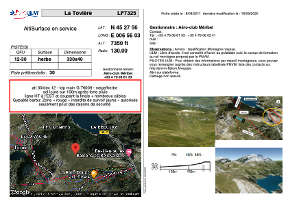


LF7325 - La Tovière
Located in Val d'Isère, France
ICAO - , IATA -
Data provided by AirmateGeneral information
Coordinates: N45°27'56" E6°56'3"
Elevation is 7350 feet MSL.
View others Airports in Rhône Alpes
Operational data
Special qualification required
Current time UTC:
Current local time:
Weather at : LIMW - Aosta ( 45 km )
METAR: LIMW 300520Z VRB01KT CAVOK 09/09 Q1012
TAF: TAF LIMW 300500Z 3006/3015 VRB05KT 9999 SCT080 BECMG 3010/3012 10015KT
Communications frequencies: [VIEW]
Runways:
| RWY identifier | QFU | Length (ft) | Width (ft) | Surface | LDA (ft) |
| 12 | 0° | 1082 | 131 | GRASS | |
| 30 | 0° | 1082 | 131 | GRASS |
Airport contact information
Address: Val d'Isère France