


KTIK - Tinker Afb
Located in Oklahoma City, United States
ICAO - TIK, IATA -
Data provided by AirmateGeneral information
Coordinates: N35°24'53" W97°23'12"
Elevation is 1290 feet MSL.
Magnetic variation is 03° East View others Airports in Oklahoma
Operational data
Special qualification required
Current time UTC:
Current local time:
Weather
METAR: KTIK 050540Z AUTO 07009KT 10SM OVC029 18/14 A2992 RMK AO2 CIG 028 RWY13 SLP130 VISNO RWY18 $
TAF: TAF AMD KTIK 050428Z 0504/0607 02012KT 9999 BKN025 BKN120 QNH2994INS BECMG 0505/0507 06009KT 9000 -SHRA VCTS OVC015CB QNH2993INS TEMPO 0507/0511 19015G25KT 6000 -TSRA OVC008CB BECMG 0513/0514 08009KT 9999 NSW BKN012 OVC100 QNH2989INS BECMG 0520/0521 VRB06KT 9999 BKN020 QNH2982INS TX25/0521Z TN15/0512Z
Communications frequencies: [VIEW]
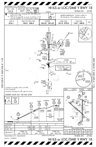
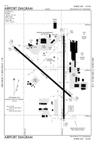
Runways:
| RWY identifier | QFU | Length (ft) | Width (ft) | Surface | LDA (ft) |
| 13 | 131° | 10000 | 200 | OTHER | |
| 31 | 311° | 10000 | 200 | OTHER | |
| 18 | 180° | 11100 | 200 | OTHER | |
| 36 | 360° | 11100 | 200 | OTHER |
Airport contact information
Address: Oklahoma City United States