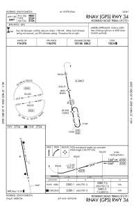
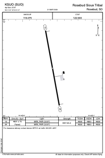


KSUO - Rosebud Sioux Tribal
Located in Rosebud, United States
ICAO - SUO, IATA -
Data provided by AirmateGeneral information
Coordinates: N43°15'30" W100°51'34"
Elevation is 2724 feet MSL.
Magnetic variation is 06° East View others Airports in South Dakota
Operational data
Special qualification required
Current time UTC:
Current local time:
Weather at : KVTN - Miller Fld ( 51 km )
METAR: KVTN 192352Z AUTO 21019G28KT 10SM CLR 24/13 A2969 RMK AO2 PK WND 20030/2320 RAE00 SLP039 P0000 60000 T02440128 10272 20239 50001
TAF: KVTN 192324Z 2000/2024 21012G25KT P6SM VCSH SCT060 BKN200 WS020/22050KT FM200200 17010KT P6SM BKN140 FM200500 32010KT P6SM SCT140 FM200800 34013G27KT P6SM SCT035 SCT150 WS020/34035KT TEMPO 2011/2014 BKN025 FM201400 35015G26KT P6SM BKN040 FM201800 02012G20KT P6SM SCT070
Communications frequencies: [VIEW]
Runways:
| RWY identifier | QFU | Length (ft) | Width (ft) | Surface | LDA (ft) |
| 16 | 170° | 4801 | 75 | CONC | 4800 |
| 34 | 350° | 4801 | 75 | CONC | 4800 |
Airport contact information
Address: Rosebud United States