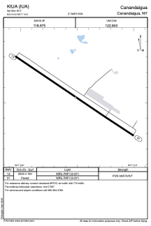


KIUA - Canandaigua
Located in Canandaigua, United States
ICAO - IUA, IATA -
Data provided by AirmateGeneral information
Coordinates: N42°54'32" W77°19'31"
Elevation is 813 feet MSL.
Magnetic variation is -12° East View others Airports in New York
Operational data
Special qualification required
Current time UTC:
Current local time:
Weather at : KROC - Frederick Douglass/Greater Rochester Intl ( 37 km )
METAR: KROC 051211Z 19010KT 2SM RA BR OVC029 12/10 A2999 RMK AO2 SFC VIS 4 RAB1155 P0000 T01220100
TAF: KROC 051120Z 0512/0612 17008KT 6SM -SHRA BR OVC025 FM051400 19011G18KT 6SM -SHRA BR OVC015 FM051700 22011G18KT P6SM VCSH OVC015 FM052000 22010KT P6SM BKN015 FM060100 22004KT 6SM -SHRA OVC012 FM060500 27005KT 4SM BR OVC015 FM060800 29004KT 2SM BR BKN015
Communications frequencies: [VIEW]
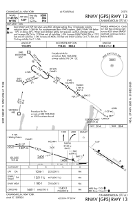
Runways:
| RWY identifier | QFU | Length (ft) | Width (ft) | Surface | LDA (ft) |
| 13 | 123° | 5500 | 100 | ASPH | |
| 31 | 303° | 5500 | 100 | ASPH |
Airport contact information
Address: Canandaigua United States