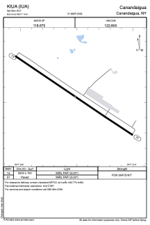


KIUA - Canandaigua
Located in Canandaigua, United States
ICAO - IUA, IATA -
Data provided by AirmateGeneral information
Coordinates: N42°54'32" W77°19'31"
Elevation is 813 feet MSL.
Magnetic variation is -12° East View others Airports in New York
Operational data
Special qualification required
Current time UTC:
Current local time:
Weather at : KROC - Frederick Douglass/Greater Rochester Intl ( 37 km )
METAR: KROC 060554Z 24005KT 10SM OVC014 17/14 A3000 RMK AO2 SLP159 60002 T01670139 10189 20156 58002
TAF: KROC 060526Z 0606/0706 24004KT P6SM VCSH OVC020 FM060800 28004KT 4SM BR BKN007 FM061000 29005KT 6SM BR BKN015 FM061200 30005KT P6SM SCT020 BKN250 FM061500 30007KT P6SM BKN250 FM061700 35008KT P6SM BKN250 FM062300 35006KT P6SM BKN250 FM070300 VRB03KT P6SM SKC
Communications frequencies: [VIEW]
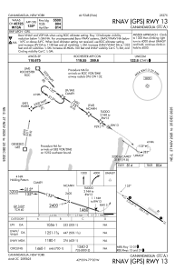
Runways:
| RWY identifier | QFU | Length (ft) | Width (ft) | Surface | LDA (ft) |
| 13 | 123° | 5500 | 100 | ASPH | |
| 31 | 303° | 5500 | 100 | ASPH |
Airport contact information
Address: Canandaigua United States