


KGUR - Camp Guernsey
Located in Guernsey, United States
ICAO - GUR, IATA -
Data provided by AirmateGeneral information
Coordinates: N42°15'35" W104°43'42"
Elevation is 4401 feet MSL.
Magnetic variation is 11° East View others Airports in Wyoming
Operational data
Special qualification required
Current time UTC:
Current local time:
Weather
METAR: KGUR 071455Z AUTO 26020G29KT 10SM CLR 10/M02 A2944 RMK AO2 PK WND 26029/49 LTG DSNT S SLP971 T01041023 52007
TAF: TAF KGUR 071300Z 0713/0819 27025G35KT 9999 SKC 510007 QNH2949INS BECMG 0716/0717 30015G25KT 9999 SKC QNH2950INS BECMG 0801/0802 29015KT 9999 SCT070 BKN100 QNH2954INS BECMG 0815/0816 29015G25KT 9999 SCT050 OVC070 QNH2971INS TX15/0721Z TN03/0812Z
Communications frequencies: [VIEW]
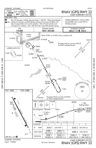
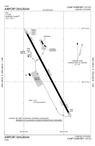
Runways:
| RWY identifier | QFU | Length (ft) | Width (ft) | Surface | LDA (ft) |
| 14 | 152° | 5060 | 90 | ASPH | |
| 32 | 332° | 5060 | 90 | ASPH |
Airport contact information
Address: Guernsey United States