


KGUR - Camp Guernsey
Located in Guernsey, United States
ICAO - GUR, IATA -
Data provided by AirmateGeneral information
Coordinates: N42°15'35" W104°43'42"
Elevation is 4401 feet MSL.
Magnetic variation is 11° East View others Airports in Wyoming
Operational data
Special qualification required
Current time UTC:
Current local time:
Communications frequencies: [VIEW]
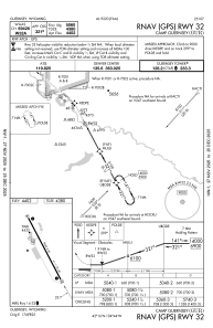
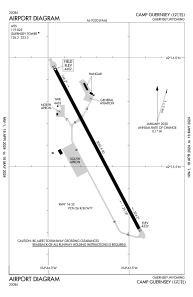
Runways:
| RWY identifier | QFU | Length (ft) | Width (ft) | Surface | LDA (ft) |
| 14 | 152° | 5060 | 90 | ASPH | |
| 32 | 332° | 5060 | 90 | ASPH |
Airport contact information
Address: Guernsey United States