


KEGE - Eagle County Rgnl
Located in Eagle, United States
ICAO - EGE, IATA - EGE
Data provided by AirmateGeneral information
Coordinates: N39°38'34" W106°54'57"
Elevation is 6547 feet MSL.
Magnetic variation is 09° East View others Airports in Colorado
Operational data
Special qualification required
Current time UTC:
Current local time:
Weather
METAR: KEGE 260656Z AUTO 10005KT 10SM OVC060 07/02 A2981 RMK AO2 SLP020 T00720017
TAF: KEGE 260520Z 2606/2706 VRB04KT P6SM -RA OVC090 FM260800 23007KT P6SM SCT045 BKN070 FM261600 24007KT P6SM FEW040 SCT080 FM262100 22011KT 6SM -SHRA BR VCTS SCT040CB BKN080 FM270000 24009KT 6SM -SHRA BR SCT050 BKN060
Communications frequencies: [VIEW]
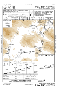
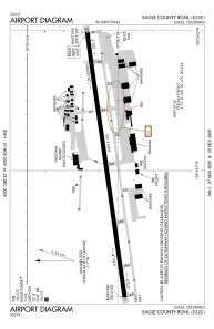
Runways:
| RWY identifier | QFU | Length (ft) | Width (ft) | Surface | LDA (ft) |
| 07 | 82° | 9000 | 150 | ASPH | 9000 |
| 25 | 262° | 9000 | 150 | ASPH | 8000 |
Airport contact information
Address: Eagle United States
