


84KS - St Mary's Airpark
Located in St. Mary's, United States
ICAO - 84KS, IATA -
Data provided by AirmateGeneral information
Coordinates: N39°16'16" W96°3'42"
Elevation is 1220 feet MSL.
View others Airports in Kansas
Operational data
Special qualification required
Current time UTC:
Current local time:
Weather at : KTOP - Philip Billard Muni ( 44 km )
TAF: KTOP 281720Z 2818/2918 19012G20KT P6SM VCSH OVC015 TEMPO 2818/2821 3SM -SHRA BR FM282200 23012KT P6SM BKN035 FM290100 27007KT P6SM SKC FM291000 28001KT 3SM MIFG SKC FM291300 28003KT P6SM SCT100
Communications frequencies: [VIEW]
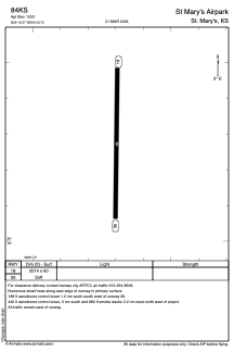
Runways:
| RWY identifier | QFU | Length (ft) | Width (ft) | Surface | LDA (ft) |
| 18 | 181° | 2514 | 60 | OTHER | |
| 36 | 1° | 2514 | 60 | OTHER |
Airport contact information
Address: St. Mary's United States