


KTOP - Philip Billard Muni
Located in Topeka, United States
ICAO - TOP, IATA -
Data provided by AirmateGeneral information
Coordinates: N39°4'8" W95°37'21"
Elevation is 881 feet MSL.
Magnetic variation is 05° East View others Airports in Kansas
Operational data
Special qualification required
Current time UTC:
Current local time:
Weather
METAR: KTOP 280821Z AUTO 10013G21KT 10SM FEW007 OVC100 17/16 A2971 RMK AO2 LTG DSNT S T01720156 PWINO $
TAF: KTOP 280532Z 2806/2906 14012KT 6SM TSRA BR OVC050CB TEMPO 2806/2809 4SM TSRA BR OVC025CB FM280900 14012KT P6SM -SHRA VCTS SCT030 OVC050CB FM281100 14012KT P6SM -SHRA BKN015 FM281400 16012KT P6SM VCSH OVC008 FM281600 18013G21KT P6SM VCTS OVC015CB
Communications frequencies: [VIEW]
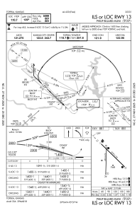
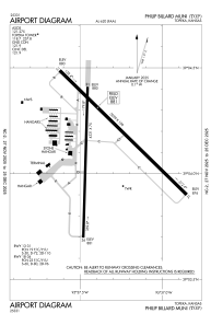
Runways:
| RWY identifier | QFU | Length (ft) | Width (ft) | Surface | LDA (ft) |
| 13 | 134° | 5099 | 100 | ASPH | |
| 31 | 314° | 5099 | 100 | ASPH | |
| 18 | 182° | 4331 | 75 | ASPH | |
| 36 | 2° | 4331 | 75 | ASPH |
Airport contact information
Address: Topeka United States
