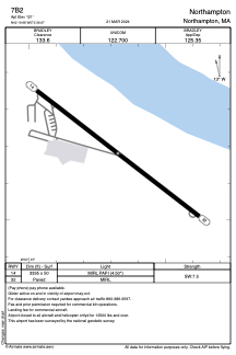


7B2 - Northampton
Located in Northampton, United States
ICAO - 7B2, IATA -
Data provided by AirmateGeneral information
Coordinates: N42°19'41" W72°36'40"
Elevation is 121 feet MSL.
Magnetic variation is -15° East View others Airports in Massachusetts
Operational data
Special qualification required
Current time UTC:
Current local time:
Weather at : KCEF - Westover Arb/Metro ( 16 km )
METAR: KCEF 262355Z 00000KT 10SM CLR 14/M10 A3037 RMK AO2A SLP291 T01441096 10163 20142 58004
TAF: TAF KCEF 270000Z 2700/2806 18006KT 9999 SCT250 QNH3036INS WND 20009KT AFT 2714 BECMG 2717/2718 20012KT 9999 BKN180 BKN220 QNH3031INS TEMPO 2718/2801 21012G20KT 510004 BECMG 2800/2801 20012KT 9999 BKN070 OVC150 510103 QNH3031INS BECMG 2802/2803 20009KT 8000 -RA BR FEW012 BKN035 OVC090 510103 QNH3025INS TX20/2720Z TN00/2710Z LAST NO AMDS AFT 2703 NEXT 2712
Communications frequencies: [VIEW]
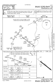
Runways:
| RWY identifier | QFU | Length (ft) | Width (ft) | Surface | LDA (ft) |
| 14 | 128° | 3335 | 50 | ASPH | |
| 32 | 308° | 3335 | 50 | ASPH |
Airport contact information
Address: Northampton United States
Other aviation service providers
Flight schools

Northampton Aeronautics, Inc.
Northampton Aeronautics, Inc.
info@northamptonairport.com+1(413)584-7980