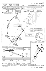
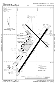


KCEF - Westover Arb/Metro
Located in Springfield/Chicopee, United States
ICAO - CEF, IATA - CEF
Data provided by AirmateGeneral information
Coordinates: N42°11'38" W72°32'5"
Elevation is 241 feet MSL.
Magnetic variation is -14° East View others Airports in Massachusetts
Operational data
Special qualification required
Current time UTC:
Current local time:
Weather
METAR: KCEF 272255Z AUTO 19016KT 10SM BKN190 BKN220 14/M04 A3030 RMK AO2 SLP268 T01391039
TAF: TAF AMD KCEF 271810Z 2718/2823 23012KT 9999 FEW070 SCT170 BKN250 QNH3034INS TEMPO 2718/2722 24012G22KT 510004 BECMG 2802/2803 18009KT 9000 -RA BR BKN030 OVC070 510405 QNH3025INS TEMPO 2804/2806 BKN010 BECMG 2805/2806 19009KT 9000 -RA BR BKN010 BKN200 QNH3020INS TEMPO 2806/2812 BKN018 BECMG 2812/2813 22009KT 9999 NSW BKN013 BKN200 QNH3005INS BECMG 2817/2818 20009KT 9999 SCT028 BKN160 QNH3001INS BECMG 2822/2823 22005KT 9000 -RA BR SCT020 BKN080 BKN130 QNH3000INS TX21/2817Z TN07/2811Z LAST NO AMDS AFT 2721 NEXT 2817
Communications frequencies: [VIEW]
Runways:
| RWY identifier | QFU | Length (ft) | Width (ft) | Surface | LDA (ft) |
| 05 | 34° | 11597 | 300 | ASPH | |
| 23 | 214° | 11597 | 300 | ASPH | |
| 15 | 135° | 7085 | 150 | ASPH | |
| 33 | 315° | 7085 | 150 | ASPH |
Airport contact information
Address: Springfield/Chicopee United States