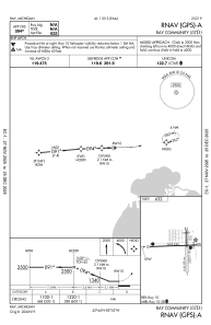


57D - Ray Community
Located in Ray, United States
ICAO - 57D, IATA -
Data provided by AirmateGeneral information
Coordinates: N42°44'12" W82°53'20"
Elevation is 632 feet MSL.
Magnetic variation is -06° East View others Airports in Michigan
Operational data
Special qualification required
Current time UTC:
Current local time:
Weather at : KMTC - Selfridge Angb ( 14 km )
METAR: KMTC 031856Z 15005KT 10SM SCT011 OVC120 18/15 A2996 RMK AO2A SLP150 T01810153 $
Communications frequencies: [VIEW]
Runways:
| RWY identifier | QFU | Length (ft) | Width (ft) | Surface | LDA (ft) |
| 01 | 359° | 2202 | 123 | OTHER | |
| 19 | 179° | 2202 | 123 | OTHER | |
| 10 | 88° | 2495 | 60 | ASPH | |
| 28 | 268° | 2495 | 60 | ASPH |
Airport contact information
Address: Ray United States
