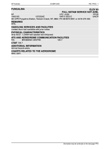


YPUG - Pungalina
Located in Tennant Creek, Australia
ICAO - , IATA -
Data provided by AirmateGeneral information
Coordinates: S16°43'19" E137°25'24"
Elevation is 200 feet MSL.
Magnetic variation is 5° East View others Airports in Northern Territory
Operational data
Special qualification required
Current time UTC:
Current local time:
Weather at : - ( 0 km )
METAR: PPIZ 100951Z AUTO 32003KT 1SM -SN BR SCT013 OVC019 M07/M08 A2988 RMK AO2 P0001 FZRANO
Communications frequencies: [VIEW]
Runways:
| RWY identifier | QFU | Length (ft) | Width (ft) | Surface | LDA (ft) |
| 09 | 0° | 0 | 0 | UNK | |
| 27 | 0° | 0 | 0 | UNK |
Airport contact information
Address: Tennant Creek Australia