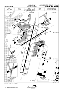


YPPH - Perth
Located in Perth, Australia
ICAO - YPPH, IATA - PER
Data provided by AirmateGeneral information
Coordinates: S31°56'25" E115°58'1"
Elevation is 67 feet MSL.
View others Airports in Western Australia
Operational data
Special qualification required
Current time UTC:
Current local time:
Weather
METAR: YPPH 100730Z 30016KT CAVOK 26/16 Q1017
TAF: TAF YPPH 100522Z 1006/1112 32014KT 9999 -SHRA SCT020 SCT030 FM101500 VRB03KT 9999 -SHRA SCT010 BKN020 BECMG 1102/1104 24008KT 9999 -SHRA SCT012 BKN025 FM110900 19005KT CAVOK INTER 1007/1018 VRB16G28KT 4000 SHRA BKN015 SCT025TCU PROB30 INTER 1008/1011 VRB25G40KT 2000 TSRA BKN015 SCT025CB
Communications frequencies: [VIEW]
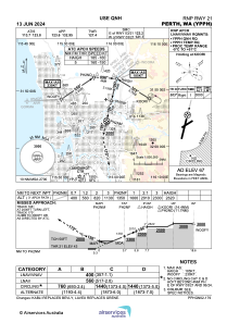
Runways:
| RWY identifier | QFU | Length (ft) | Width (ft) | Surface | LDA (ft) |
| 03 | 14° | 11299 | 148 | ASP | |
| 21 | 194° | 11299 | 148 | ASP | |
| 06 | 59° | 7096 | 148 | ASP | |
| 24 | 239° | 7096 | 148 | ASP |
Airport contact information
Address: Perth Australia
Other aviation service providers
Aviation club (not for profit)

Gliding Club Of Western Australia
Gliding Club Of Western Australia
gcwa@westnet.com.au+61409683159
+61409683159
+61409683159