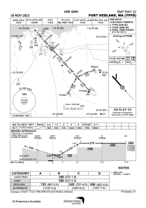
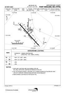


YPPD - Port Hedland
Located in Port Hedland, Australia
ICAO - YPPD, IATA - PHE
Data provided by AirmateGeneral information
Coordinates: S20°22'40" E118°37'35"
Elevation is 33 feet MSL.
View others Airports in Western Australia
Operational data
Special qualification required
Current time UTC:
Current local time:
Weather
METAR: YPPD 092030Z AUTO 16007KT 9999 // NCD 18/04 Q1016 RF00.0////./
TAF: TAF YPPD 091709Z 0918/1018 14008KT CAVOK FM100000 09016KT CAVOK BECMG 1003/1005 04014KT CAVOK FM101000 36008KT CAVOK FM101400 14008KT CAVOK
Communications frequencies: [VIEW]
Runways:
| RWY identifier | QFU | Length (ft) | Width (ft) | Surface | LDA (ft) |
| 14 | 137° | 8202 | 148 | ASP | |
| 32 | 317° | 8202 | 148 | ASP | |
| 18 | 182° | 3281 | 59 | ASP | |
| 36 | 2° | 3281 | 59 | ASP |
Airport contact information
Address: Port Hedland Australia
