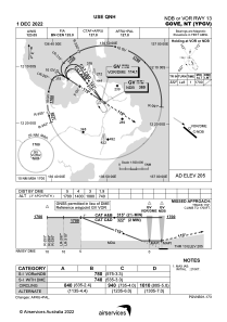
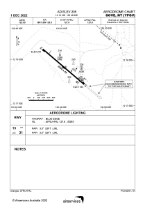


YPGV - Gove
Located in Nhulunbuy, Australia
ICAO - YPGV, IATA - GOV
Data provided by AirmateGeneral information
Coordinates: S12°16'9" E136°49'6"
Elevation is 205 feet MSL.
View others Airports in Northern Territory
Operational data
Special qualification required
Current time UTC:
Current local time:
Weather
METAR: YPGV 092030Z AUTO 13011KT 9999 // SCT025 26/23 Q1012 RF00.0/001.0
TAF: TAF YPGV 091923Z 0920/1008 13010KT 9999 SCT020 FM100000 12016KT 9999 SCT025 INTER 0921/1003 3000 SHRA BKN010
Communications frequencies: [VIEW]
Runways:
| RWY identifier | QFU | Length (ft) | Width (ft) | Surface | LDA (ft) |
| 13 | 130° | 7244 | 148 | ASP | |
| 31 | 310° | 7244 | 148 | ASP |
Airport contact information
Address: Nhulunbuy Australia