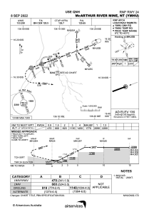
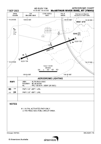


YMHU - Mcarthur River Mine
Located in Winnellie, Australia
ICAO - YMHU, IATA - MCV
Data provided by AirmateGeneral information
Coordinates: S16°26'36" E136°4'36"
Elevation is 136 feet MSL.
View others Airports in Northern Territory
Operational data
Special qualification required
Current time UTC:
Current local time:
Weather at : - ( 0 km )
METAR: KEFD 091054Z 13006KT 4SM BR BKN012010 OVC022 26/25 A2967
Communications frequencies: [VIEW]
Runways:
| RWY identifier | QFU | Length (ft) | Width (ft) | Surface | LDA (ft) |
| 06 | 69° | 8202 | 98 | ASP | |
| 24 | 249° | 8202 | 98 | ASP |
Airport contact information
Address: Winnellie Australia