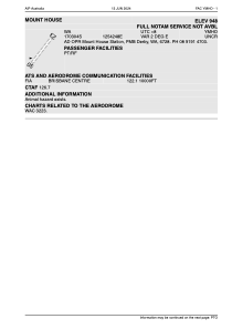


YMHO - Mount House
Located in Derby, Australia
ICAO - YMHO, IATA - MHO
Data provided by AirmateGeneral information
Coordinates: S17°3'5" E125°42'49"
Elevation is 948 feet MSL.
Magnetic variation is 2° East View others Airports in Western Australia
Operational data
Special qualification required
Current time UTC:
Current local time:
Weather at : - ( 0 km )
METAR: PASH 092148Z AUTO 31007KT 1 3/4SM -SN BR OVC016 M02/M03 A2987 RMK AO2 P0000 FZRANO
Communications frequencies: [VIEW]
Runways:
| RWY identifier | QFU | Length (ft) | Width (ft) | Surface | LDA (ft) |
| 03 | 0° | 0 | 0 | UNK | |
| 21 | 0° | 0 | 0 | UNK | |
| 23 | 236° | 3503 | 85 | DIRT | |
| 05 | 56° | 3503 | 85 | DIRT |
Airport contact information
Address: Derby Australia