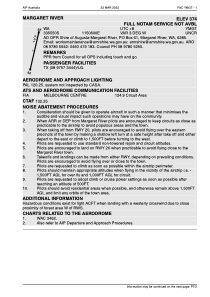


YMGT - Margaret River
Located in Margaret River, Australia
ICAO - YMGT, IATA - MQZ
Data provided by AirmateGeneral information
Coordinates: S33°55'51" E115°5'59"
Elevation is 374 feet MSL.
Magnetic variation is -3° East View others Airports in Western Australia
Operational data
Special qualification required
Current time UTC:
Current local time:
Weather at : YBLN - Busselton ( 39 km )
METAR: YBLN 101200Z AUTO 27004KT 9999 // NCD 17/14 Q1018 RF00.0/007.6
TAF: TAF YBLN 101124Z 1012/1112 26005KT 9999 -SHRA SCT020 BKN030 FM101500 16005KT 9999 -SHRA SCT030 FM110000 25005KT 9999 NSW SCT045
Communications frequencies: [VIEW]
Runways:
| RWY identifier | QFU | Length (ft) | Width (ft) | Surface | LDA (ft) |
| 02 | 19° | 3619 | 49 | ASP | |
| 20 | 199° | 3619 | 49 | ASP |
Airport contact information
Address: Margaret River Australia