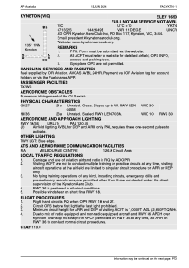


YKTN - Kyneton (Vic)
Located in Kyneton, Australia
ICAO - YKTN, IATA -
Data provided by AirmateGeneral information
Coordinates: S37°13'32" E144°26'49"
Elevation is 1650 feet MSL.
Magnetic variation is 11° East View others Airports in Victoria
Operational data
Special qualification required
Current time UTC:
Current local time:
Weather at : YMML - Melbourne ( 61 km )
METAR: YMML 091430Z 34001KT 9999 FEW007 BKN052 BKN090 13/12 Q1030 RF00.0/006.8
TAF: TAF YMML 091113Z 0912/1018 27005KT 9999 -RA FEW008 SCT025 BECMG 0916/0918 33005KT 9999 -RA BKN008 BECMG 1000/1001 16005KT 9999 -RA SCT010 BKN025 FM100300 16008KT 9999 -RA SCT030 FM100900 22005KT 9999 NSW SCT015 FM101200 27005KT 9999 SCT010 TEMPO 0912/0916 5000 RA BKN008 TEMPO 0916/0923 4000 RA BKN004 TEMPO 1015/1018 9999 BKN008
Communications frequencies: [VIEW]
Runways:
| RWY identifier | QFU | Length (ft) | Width (ft) | Surface | LDA (ft) |
| 18 | 0° | 2306 | 33 | X | |
| 36 | 0° | 2306 | 33 | X | |
| 09 | 0° | 2116 | 98 | G | |
| 27 | 0° | 2116 | 98 | G |
Airport contact information
Address: Kyneton Australia
