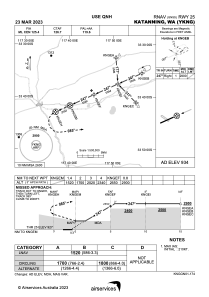
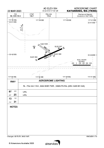


YKNG - Katanning
Located in Katanning, Australia
ICAO - YKNG, IATA - KNI
Data provided by AirmateGeneral information
Coordinates: S33°42'1" E117°39'12"
Elevation is 932 feet MSL.
View others Airports in Western Australia
Operational data
Special qualification required
Current time UTC:
Current local time:
Weather at : - ( 0 km )
METAR: KUNV 092253Z 05008KT 3SM RA BR SCT031 OVC041 12/11 A2972
Communications frequencies: [VIEW]
Runways:
| RWY identifier | QFU | Length (ft) | Width (ft) | Surface | LDA (ft) |
| 07 | 66° | 4921 | 75 | UNK | |
| 25 | 246° | 4921 | 75 | UNK | |
| 13 | 130° | 3284 | 59 | UNK | |
| 31 | 310° | 3284 | 59 | UNK |
Airport contact information
Address: Katanning Australia