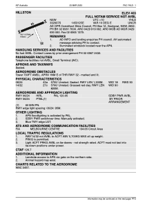


YHLS - Hillston
Located in Hillston, Australia
ICAO - YHLS, IATA -
Data provided by AirmateGeneral information
Coordinates: S33°29'39" E145°31'26"
Elevation is 403 feet MSL.
Magnetic variation is 10° East View others Airports in New South Wales
Operational data
Special qualification required
Current time UTC:
Current local time:
Weather at : - ( 0 km )
METAR: PAMD 091632Z AUTO 18005KT 10SM BKN012 OVC041 04/03 A2990 RMK AO2 RAB08E31 P0000
Communications frequencies: [VIEW]
Runways:
| RWY identifier | QFU | Length (ft) | Width (ft) | Surface | LDA (ft) |
| 14 | 151° | 2690 | 295 | GRS | |
| 32 | 331° | 2690 | 295 | GRS | |
| 06 | 72° | 4265 | 59 | ASP | |
| 24 | 252° | 4265 | 59 | ASP |
Airport contact information
Address: Hillston Australia