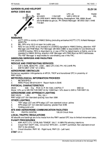


YGAD - Garden Island Heliport
Located in Rockingham, Australia
ICAO - YGAD, IATA -
Data provided by AirmateGeneral information
Coordinates: S32°14'26" E115°41'13"
Elevation is 30 feet MSL.
Magnetic variation is -2° East View others Airports in Western Australia
Operational data
Special qualification required
Current time UTC:
Current local time:
Weather at : YPJT - Perth / Jandakot ( 24 km )
METAR: YPJT 100630Z AUTO 33017KT 9999 // NCD 26/17 Q1016 RF00.0/000.0
TAF: TAF YPJT 100521Z 1006/1100 32014KT 9999 -SHRA SCT020 SCT030 FM101500 VRB03KT 9999 -SHRA SCT010 BKN020 INTER 1007/1018 VRB16G28KT 4000 SHRA BKN015 SCT025TCU PROB30 INTER 1008/1011 VRB25G40KT 2000 TSRA BKN015 SCT025CB
Communications frequencies: [VIEW]
Runways:
| RWY identifier | QFU | Length (ft) | Width (ft) | Surface | LDA (ft) |
| 05 | 0° | 1476 | 112 | UNK | |
| 23 | 0° | 1476 | 112 | UNK |
Airport contact information
Address: Rockingham Australia