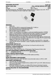


YENO - Enoggera Heliport
Located in , Australia
ICAO - YENO, IATA -
Data provided by AirmateGeneral information
Coordinates: S27°25'36" E152°58'12"
Elevation is 145 feet MSL.
View others Airports in Queensland
Operational data
Special qualification required
Current time UTC:
Current local time:
Weather at : YBBN - Brisbane ( 15 km )
METAR: YBBN 090100Z 14010KT 9999 BKN025 SCT032 BKN250 23/17 Q1026 RF00/0/000/0
TAF: TAF YBBN 082307Z 0900/1006 12012KT 9999 -SHRA SCT030 FM090900 20007KT 9999 -SHRA SCT030 FM100000 12012KT 9999 -SHRA SCT030 INTER 0902/0912 4000 SHRA SCT015
Communications frequencies: [VIEW]
Runways:
| RWY identifier | QFU | Length (ft) | Width (ft) | Surface | LDA (ft) |
| 03 | 0° | 3608 | 0 | G | |
| 21 | 0° | 3608 | 0 | G |
Airport contact information
Address: Australia