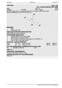


YCTA - Coolatai
Located in , Australia
ICAO - , IATA -
Data provided by AirmateGeneral information
Coordinates: S29°8'39" E150°43'29"
Elevation is 1199 feet MSL.
View others Airports in New South Wales
Operational data
Special qualification required
Current time UTC:
Current local time:
Weather at : - ( 0 km )
METAR: PAOO 091005Z AUTO 24010KT 9SM -SN BKN008 OVC013 M03/M04 A2988 RMK AO2 CIG 005V011 P0000 FZRANO TSNO $
Communications frequencies: [VIEW]
Runways:
| RWY identifier | QFU | Length (ft) | Width (ft) | Surface | LDA (ft) |
| 02 | 0° | 0 | 0 | UNK | |
| 20 | 0° | 0 | 0 | UNK | |
| 14 | 0° | 0 | 0 | UNK | |
| 32 | 0° | 0 | 0 | UNK |
Airport contact information
Address: Australia