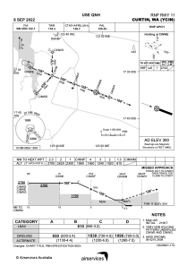
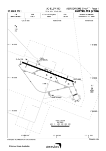


YCIN - Curtin
Located in Derby, Australia
ICAO - YCIN, IATA - DCN
Data provided by AirmateGeneral information
Coordinates: S17°34'53" E123°49'42"
Elevation is 300 feet MSL.
View others Airports in Western Australia
Operational data
Special qualification required
Current time UTC:
Current local time:
Weather
METAR: YCIN 091800Z AUTO 12009KT 9999 // NCD 23/07 Q1014 RF00.0/000.0
TAF: TAF YCIN 091224Z 0914/1002 14010KT CAVOK BECMG 1000/1002 08012KT CAVOK
Communications frequencies: [VIEW]
Runways:
| RWY identifier | QFU | Length (ft) | Width (ft) | Surface | LDA (ft) |
| 11 | 110° | 10003 | 148 | ASP | |
| 29 | 290° | 10003 | 148 | ASP |
Airport contact information
Address: Derby Australia