


YBUN - Bunbury
Located in Bunbury, Australia
ICAO - YBUN, IATA - BUY
Data provided by AirmateGeneral information
Coordinates: S33°22'41" E115°40'37"
Elevation is 53 feet MSL.
View others Airports in Western Australia
Operational data
Special qualification required
Current time UTC:
Current local time:
Weather at : YBLN - Busselton ( 43 km )
TAF: TAF AMD YBLN 092316Z 0923/1100 36014KT 9999 -SHRA SCT020 BKN025 FM100200 33018G28KT 9999 -SHRA SCT020 BKN030 FM101000 28008KT 9999 -SHRA SCT020 BKN030 FM101500 VRB05KT 9999 NSW SCT030 INTER 0923/1012 VRB30G40KT 2000 TSRA BKN010 SCT025CB
Communications frequencies: [VIEW]
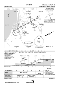
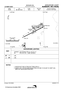
Runways:
| RWY identifier | QFU | Length (ft) | Width (ft) | Surface | LDA (ft) |
| 07 | 63° | 3999 | 59 | ASP | |
| 25 | 243° | 3999 | 59 | ASP |
Airport contact information
Address: Bunbury Australia

