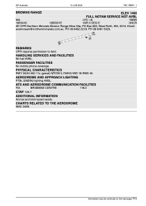


YBNR - Browns Range
Located in , Australia
ICAO - , IATA -
Data provided by AirmateGeneral information
Coordinates: S18°53'44" E128°56'31"
Elevation is 1466 feet MSL.
View others Airports in Western Australia
Operational data
Special qualification required
Current time UTC:
Current local time:
Weather at : - ( 0 km )
METAR: PAFS 090401Z AUTO 00000KT 10SM CLR 11/00 A2967 RMK AO2 SLP055 T01110000
Communications frequencies: [VIEW]
Runways:
| RWY identifier | QFU | Length (ft) | Width (ft) | Surface | LDA (ft) |
| 06 | 0° | 1100 | 59 | UNK | |
| 24 | 0° | 1100 | 59 | UNK |
Airport contact information
Address: Australia