
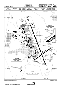


YAMB - Amberley
Located in Amberley, Australia
ICAO - YAMB, IATA -
Data provided by AirmateGeneral information
Coordinates: S27°38'26" E152°42'43"
Elevation is 91 feet MSL.
View others Airports in Queensland
Operational data
Special qualification required
Current time UTC:
Current local time:
Weather
METAR: YAMB 080530Z 15007KT 9999 SCT035 BKN065 22/15 Q1023 RF00.0/000.2
TAF: TAF YAMB 080534Z 0806/0906 13013KT 9999 -SHRA SCT035 BKN045 FM080900 19006KT 9999 NSW SCT030 FM082300 16012KT 9999 BKN035 FM090300 10012KT 9999 -SHRA BKN040
Communications frequencies: [VIEW]
Runways:
| RWY identifier | QFU | Length (ft) | Width (ft) | Surface | LDA (ft) |
| 04 | 54° | 4997 | 148 | PEM | |
| 22 | 234° | 4997 | 148 | PEM | |
| 15 | 159° | 9997 | 148 | PEM | |
| 33 | 339° | 9997 | 148 | PEM |
Airport contact information
Address: Amberley Australia
