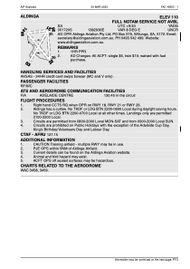


YADG - Aldinga
Located in Aldinga, Australia
ICAO - YADG, IATA -
Data provided by AirmateGeneral information
Coordinates: S35°17'20" E138°29'39"
Elevation is 111 feet MSL.
Magnetic variation is 8° East View others Airports in South Australia
Operational data
Special qualification required
Current time UTC:
Current local time:
Weather at : YPAD - Adelaide ( 38 km )
METAR: YPAD 122130Z 04005KT 9999 BKN013 10/08 Q1025
TAF: TAF AMD YPAD 122034Z 1221/1400 02005KT 9999 BKN012 FM122200 04008KT 9999 SCT012 FM130200 24008KT 9999 FEW030 FM131000 16007KT 9999 SCT012 BKN020 TEMPO 1222/1301 9999 BKN012
Communications frequencies: [VIEW]
Runways:
| RWY identifier | QFU | Length (ft) | Width (ft) | Surface | LDA (ft) |
| 14 | 0° | 2556 | 30 | unsealed | |
| 32 | 0° | 2556 | 30 | unsealed | |
| 08 | 0° | 1456 | 30 | grass | |
| 26 | 0° | 1456 | 30 | grass | |
| 18 | 0° | 1931 | 30 | grass | |
| 36 | 0° | 1931 | 30 | grass | |
| 21 | 215° | 0 | 0 | ASPH | |
| 03 | 35° | 0 | 0 | ASPH | |
| 13 | 141° | 0 | 0 | DIRT | |
| 31 | 321° | 0 | 0 | DIRT |
Airport contact information
Address: Aldinga Australia

