
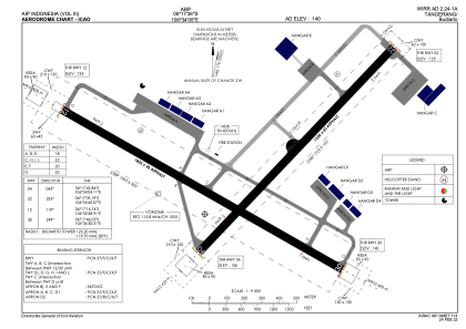


WIRR - Tangerang / Budiarto
Located in Tangerang, Indonesia
ICAO - , IATA -
Data provided by AirmateGeneral information
Coordinates: S6°17'36" E106°34'5"
Elevation is 140 feet MSL.
View others Airports in Banten
Operational data
Special qualification required
Current time UTC:
Current local time:
Weather at : WIII - Jakarta / Soekarno Hatta Intl ( 21 km )
METAR: WIII 161130Z 08011KT 8000 SCT020 29/25 Q1009 NOSIG
TAF: TAF WIII 161100Z 1612/1718 05010KT 8000 SCT020 TEMPO 1614/1618 21008KT 4000 TSRA FEW017CB BKN019 BECMG 1618/1619 VRB02KT 5000 HZ BECMG 1623/1701 05010KT 8000 NSW
Communications frequencies: [VIEW]
Runways:
| RWY identifier | QFU | Length (ft) | Width (ft) | Surface | LDA (ft) |
| 12 | 120° | 5981 | 148 | UNK | |
| 30 | 300° | 5981 | 148 | UNK | |
| 04 | 44° | 5249 | 148 | UNK | |
| 22 | 224° | 5249 | 148 | UNK |
Airport contact information
Address: Tangerang Indonesia