


WIPP - Palembang/Sultan Mahmud Badaruddin Ii
Located in Palembang, Indonesia
ICAO - WIPP, IATA - PLM
Data provided by AirmateGeneral information
Coordinates: S2°54'1" E104°42'0"
Elevation is 49 feet MSL.
View others Airports in Sumatra Selatan
Operational data
Special qualification required
Current time UTC:
Current local time:
Weather
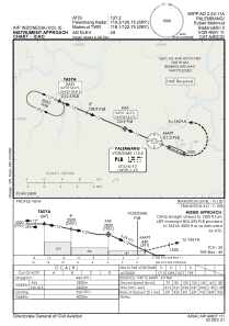
METAR: WIPP 030200Z 19004KT 140V240 9999 FEW010 29/26 Q1010 NOSIG
TAF: TAF WIPP 022300Z 0300/0324 14007KT 9999 SCT010 TEMPO 0305/0309 3000 TSRA FEW010CB BKN011 TEMPO 0320/0324 3000 BR
Communications frequencies: [VIEW]
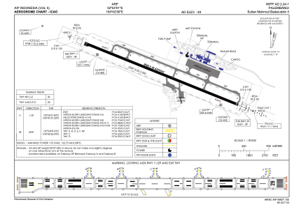
Runways:
| RWY identifier | QFU | Length (ft) | Width (ft) | Surface | LDA (ft) |
| 11 | 113° | 9843 | 148 | ASP | |
| 29 | 293° | 9843 | 148 | ASP |
Airport contact information
Address: Palembang Indonesia