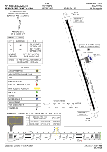


WAWH - Selayar / H. Aroeppala
Located in Benteng, Indonesia
ICAO - WAWH, IATA - KSR
Data provided by AirmateGeneral information
Coordinates: S6°10'36" E120°26'14"
Elevation is 23 feet MSL.
View others Airports in Sulawesi Selatan
Operational data
Special qualification required
Current time UTC:
Current local time:
Weather at : - ( 0 km )
METAR: CYGR 292023Z 33020G25KT 20SM BKN005 BKN060 04/02 A2987 RMK SF5SC2 SLP118
Communications frequencies: [VIEW]
Runways:
| RWY identifier | QFU | Length (ft) | Width (ft) | Surface | LDA (ft) |
| 16 | 158° | 6398 | 98 | UNK | |
| 34 | 338° | 6398 | 98 | UNK |
Airport contact information
Address: Benteng Indonesia