


WATC - Maumere / Fransiskus Xaverius Seda
Located in Maumere, Indonesia
ICAO - WATC, IATA - MOF
Data provided by AirmateGeneral information
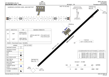
Coordinates: S8°38'15" E122°14'13"
Elevation is 175 feet MSL.
View others Airports in Nusa Tenggara Timur
Operational data
Special qualification required
Current time UTC:
Current local time:
Weather at : - ( 0 km )
METAR: ROTM 040256Z 12009KT 9999 FEW025 BKN130 28/22 A2995 RMK SLP142 T02780220 54003
Communications frequencies: [VIEW]
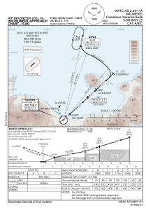
Runways:
| RWY identifier | QFU | Length (ft) | Width (ft) | Surface | LDA (ft) |
| 05 | 51° | 7382 | 148 | ASP | |
| 23 | 231° | 7382 | 148 | ASP |
Airport contact information
Address: Maumere Indonesia