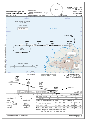


WARW - Bawean / Harun Thohir
Located in Tambak, Indonesia
ICAO - , IATA - BXW
Data provided by AirmateGeneral information
Coordinates: S5°43'25" E112°40'36"
Elevation is 180 feet MSL.
View others Airports in Jawa Timur
Operational data
Special qualification required
Current time UTC:
Current local time:
Weather at : - ( 0 km )
METAR: CYWK 030552Z AUTO 05007KT 1 3/4SM -FZRA -SN OVC011 M02/M02 A3033 RMK ICE SLP307
Communications frequencies: [VIEW]
Runways:
| RWY identifier | QFU | Length (ft) | Width (ft) | Surface | LDA (ft) |
| 09 | 91° | 3051 | 75 | UNK | |
| 27 | 271° | 3051 | 75 | UNK |
Airport contact information
Address: Tambak Indonesia