


WARP - Pulau Pagerungan Besar/Pagerungan
Located in , Indonesia
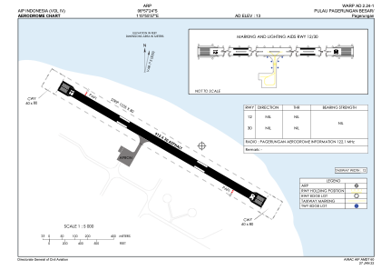
ICAO - , IATA -
Data provided by AirmateGeneral information
Coordinates: S6°57'24" E115°55'57"
Elevation is 13 feet MSL.
Magnetic variation is 1° East View others Airports in Jawa Timur
Operational data
Special qualification required
Current time UTC:
Current local time:
Weather at : - ( 0 km )
METAR: KLZU 150528Z AUTO 00000KT 1 3/4SM BR CLR A2975 RMK AO2 VIS 1/2V5 FZRANO $
Communications frequencies: [VIEW]
Runways:
| RWY identifier | QFU | Length (ft) | Width (ft) | Surface | LDA (ft) |
| 12 | 0° | 3002 | 98 | UNK | |
| 30 | 0° | 3002 | 98 | UNK |
Airport contact information
Address: Indonesia