


WARC - Blora / Ngloram
Located in Cepu, Indonesia
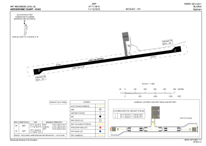
ICAO - WARC, IATA - CPE
Data provided by AirmateGeneral information
Coordinates: S7°11'39" E111°32'50"
Elevation is 141 feet MSL.
View others Airports in Jawa Tengah
Operational data
Special qualification required
Current time UTC:
Current local time:
Weather at : - ( 0 km )
METAR: K40B 281417Z AUTO VRB06G11KT 08/05 A3005 RMK AO1 SLP186 T00820045 58012 P0002
Communications frequencies: [VIEW]
Runways:
| RWY identifier | QFU | Length (ft) | Width (ft) | Surface | LDA (ft) |
| 08 | 83° | 4921 | 98 | ASP | |
| 26 | 263° | 4921 | 98 | ASP |
Airport contact information
Address: Cepu Indonesia