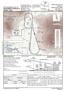
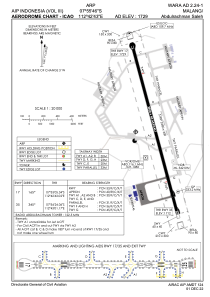


WARA - Malang / Abdulrachman Saleh
Located in Malang, Indonesia
ICAO - WARA, IATA - MLG
Data provided by AirmateGeneral information
Coordinates: S7°55'46" E112°42'43"
Elevation is 1726 feet MSL.
View others Airports in Jawa Timur
Operational data
Special qualification required
Current time UTC:
Current local time:
Weather at : WARR - Surabaya/Juanda ( 62 km )
METAR: WARR 152330Z VRB01KT 5000 HZ FEW020 25/23 Q1010 NOSIG
TAF: TAF WARR 152300Z 1600/1700 10012KT 9999 FEW020 BECMG 1618/1620 24004KT 5000 HZ
Communications frequencies: [VIEW]
Runways:
| RWY identifier | QFU | Length (ft) | Width (ft) | Surface | LDA (ft) |
| 17 | 166° | 8202 | 131 | ASP | |
| 35 | 346° | 8202 | 131 | ASP |
Airport contact information
Address: Malang Indonesia