


WAPP - Ambon/Pattimura
Located in Ambon, Indonesia
ICAO - WAPP, IATA - AMQ
Data provided by AirmateGeneral information
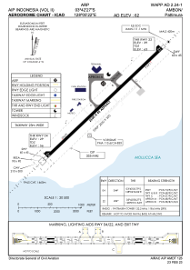
Coordinates: S3°42'27" E128°5'22"
Elevation is 62 feet MSL.
View others Airports in Maluku
Operational data
Special qualification required
Current time UTC:
Current local time:
Weather
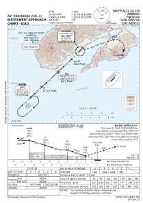
METAR: WAPP 281300Z 34008KT 7000 -RA FEW015CB SCT016 27/25 Q1009 NOSIG
TAF: TAF WAPP 281100Z 2812/2912 35007KT 9999 SCT017 TEMPO 2814/2817 5000 TSRA FEW015CB
Communications frequencies: [VIEW]
Runways:
| RWY identifier | QFU | Length (ft) | Width (ft) | Surface | LDA (ft) |
| 04 | 45° | 8202 | 148 | ASP | |
| 22 | 225° | 8202 | 148 | ASP |
Airport contact information
Address: Ambon Indonesia