


WALE - Kutai Barat / Melalan Melak
Located in Barong Tongkok, Indonesia
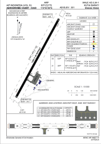
ICAO - WALE, IATA - GHS
Data provided by AirmateGeneral information
Coordinates: S0°12'21" E115°45'38"
Elevation is 331 feet MSL.
View others Airports in East Kalimantan
Operational data
Special qualification required
Current time UTC:
Current local time:
Weather at : - ( 0 km )
METAR: KTIX 282047Z 09010KT 7SM BKN040 27/13 A3017
Communications frequencies: [VIEW]
Runways:
| RWY identifier | QFU | Length (ft) | Width (ft) | Surface | LDA (ft) |
| 03 | 29° | 4265 | 98 | Compacted sand | |
| 21 | 209° | 4265 | 98 | Compacted sand |
Airport contact information
Address: Barong Tongkok Indonesia