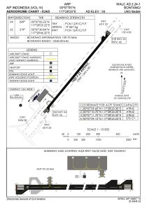


WALC - Bontang / Lng Badak
Located in Bontang, Indonesia
ICAO - , IATA - BXT
Data provided by AirmateGeneral information
Coordinates: N0°7'5" E117°28'25"
Elevation is 56 feet MSL.
View others Airports in East Kalimantan
Operational data
Special qualification required
Current time UTC:
Current local time:
Weather at : WALS - Samarinda / Aji Pangeran Tumenggung Pranoto ( 60 km )
TAF: TAF WALS 282300Z 2900/2912 33005KT 3000 BR SCT015 BECMG 2901/2903 9999 NSW
Communications frequencies: [VIEW]
Runways:
| RWY identifier | QFU | Length (ft) | Width (ft) | Surface | LDA (ft) |
| 04 | 39° | 3346 | 75 | UNK | |
| 22 | 219° | 3346 | 75 | UNK |
Airport contact information
Address: Bontang Indonesia