


WAFS - Mamasa / Sumarorong
Located in Mamasa, Indonesia
ICAO - , IATA -
Data provided by AirmateGeneral information
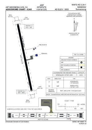
Coordinates: S3°8'52" E119°18'12"
Elevation is 3033 feet MSL.
View others Airports in Sulawesi Selatan
Operational data
Special qualification required
Current time UTC:
Current local time:
Weather at : - ( 0 km )
METAR: CYYW 292301Z AUTO 10009KT 1 1/2SM -FZRA -SN BKN009 OVC013 M01/M02 A2993 RMK VIS VRB 1 1/4-2 1/4 ICE SLP157
Communications frequencies: [VIEW]
Runways:
| RWY identifier | QFU | Length (ft) | Width (ft) | Surface | LDA (ft) |
| 17 | 168° | 3773 | 98 | UNK | |
| 35 | 348° | 3773 | 98 | UNK |
Airport contact information
Address: Mamasa Indonesia