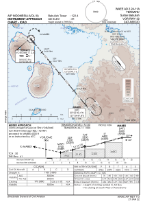


WAEE - Ternate / Sultan Babullah
Located in Ternate, Indonesia
ICAO - , IATA - TTE
Data provided by AirmateGeneral information
Coordinates: N0°49'52" E127°22'49"
Elevation is 81 feet MSL.
View others Airports in Maluku Utara
Operational data
Special qualification required
Current time UTC:
Current local time:
Weather at : - ( 0 km )
METAR: CYQZ 161638Z AUTO VRB02KT 9SM FEW014 BKN022 BKN026 OVC042 11/07 A2965 RMK SLP053 DENSITY ALT 2000FT
Communications frequencies: [VIEW]
Runways:
| RWY identifier | QFU | Length (ft) | Width (ft) | Surface | LDA (ft) |
| 14 | 141° | 7546 | 148 | UNK | |
| 32 | 321° | 7546 | 148 | UNK |
Airport contact information
Address: Ternate Indonesia